What Auckland’s updated flood mapping really means for property owners and developers
In November 2025, Auckland Council notified Proposed Plan Change 120 (PC120): Housing Intensification and Resilience, introducing significant changes to how natural hazards, particularly flooding, are identified and managed across the region.
While PC120 is widely known for enabling housing intensification around rapid transit routes and centres, it also introduced updated flood hazard mapping that has prompted questions and concern from many landowners, developers, and homeowners.
At CKL, we have been supporting clients through this transition by providing flood assessments that help translate high-level council mapping into clear, site-specific understanding.
What has changed with flood mapping under PC120?
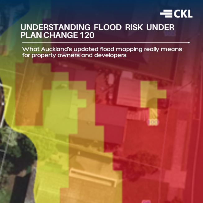
One of the most significant updates under PC120 is the approach to flood modelling.
The new mapping applies a worst-case climate change scenario to a 1-in-100-year rainfall event. This represents a shift from earlier modelling assumptions, which were based on a more moderate climate scenario and a shorter future timeframe.
In practical terms, this means:
- Flood extents are shown as larger
- Flood depths may appear greater
- Overland Flow Paths (OLFPs) have expanded in some areas
It’s important to understand that these maps are intentionally conservative. They are designed to support long-term resilience planning, rather than reflect day-to-day or historical flooding patterns.
Why flood maps don’t tell the whole story
Council flood mapping is developed at a city-wide scale, using standardised assumptions to model thousands of sites consistently. While this is necessary for strategic planning, it also means the maps:
- Only partially account for local ground conditions
- Do not reflect site-specific drainage features
- Cannot assess floor levels, access routes, or safe egress
In reality, flood mapping is a starting point, not a final answer.
The role of flood assessments
To help clients navigate PC120, CKL has undertaken a range of flood assessments tailored to different needs and levels of risk.
These include:
Detailed site-specific flood modelling
A highly technical assessment using the same parameters as council models but applied specifically to an individual site. This approach can:
- Refine predicted flood extents and depths
- Inform finished floor levels for new buildings
- Support consenting pathways for development
- Assess the likelihood of floodwater entering habitable floor levels
- Confirm whether safe egress is available during a flood event
- Provide confidence for homeowners, buyers, or future consent processes
Existing sites vs new development
Flood risk is considered differently depending on whether a site is:
- An existing dwelling, or
- A new build or intensified development
- Inundation risk to current floor levels
- Emergency access and evacuation routes
- Providing reassurance and documentation for future property sales
In both cases, the goal is the same: understanding risk and managing it appropriately, rather than avoiding development altogether.
Can flood mapping be challenged?
During the initial submission period (which closed on 19 December 2025), many landowners explored whether updated flood designations could be removed or amended.
In most cases, changes to the mapping are only considered where there is clear evidence of an error. This reflects the fact that the current maps are based on conservative, region-wide assumptions rather than site-specific detail.
However, even where mapping cannot be changed, a flood assessment can still:
- Clarify actual risk at a site level
- Demonstrate safe building and access outcomes
- Sit on a council property file or be retained for future transactions
What property owners and developers should do next
If your property is affected by updated flood mapping under PC120:
1. Don’t panic — mapped flood risk does not automatically prevent development
2. Seek site-specific advice rather than relying solely on high-level maps
3. Understand your options early, particularly ahead of future submissions or consent applications
Flood risk is now a more visible and important part of planning in Auckland. With the right information, it can be managed in a practical and proportionate way.
How CKL can help
CKL supports landowners and developers with:
- Flood hazard risk assessments
- Detailed flood modelling
- Advice on PC120 implications
- Support for submissions and consenting pathways