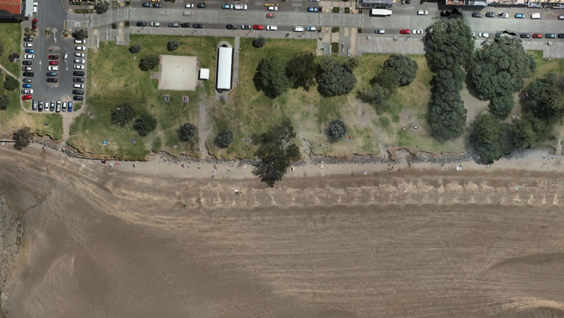
Following the extreme weather events triggered by Cyclone Gabrielle this year, CKL was asked by Auckland Council to conduct three critical topographical mapping projects of the seawalls at Brown's Bay, Waiwera and Orewa. These projects will provide indispensable data for emergency responses and long-term adaptation planning.
The Ability to Act Fast When Needed
CKL's exceptional ability to react swiftly to Auckland Council's urgent need for surveys, with only two days' notice, underscores our commitment to being an agile and responsive partner to our clients, especially in emergency scenarios.
Director Campbell Burrows emphasises the importance of CKL's quick response as the initial step in the adaptation planning process.
"The work CKL has done in topographically mapping the beaches provides valuable data that Auckland Council can leverage to craft robust adaptation planning frameworks and drive better decision-making and planning for the communities they are supporting."
“CKL's agility stems from the strength of our large team of surveyors and the diverse skill sets within our organisation. With a substantial pool of talent to draw from, CKL has the flexibility to swiftly allocate staff and equipment across projects, ensuring timely coverage for existing commitments and rapid responses to emergency or urgent requests. We take pride in our long-standing commitment to being agile and nimble, consistently meeting the dynamic needs of our clients."
Utilising Cutting-Edge Technology for Accurate Data Capture
Conducting topographical mapping of beaches presents challenges in sometimes dangerous and difficult-to-access environments. We addressed these challenges by employing a LiDAR integrated drone, effectively eliminating associated health and safety risks, and ensuring accurate mapping of vast distances, even in the presence of complex landforms.
An early adopter of the technology in New Zealand, we have been using LiDAR for various projects, including flood modelling in Flat Bush in Takanini, and knew that it would deliver quick and accurate 3D modelling of the seawalls that would provide Auckland Council with the data they urgently need.
Providing Nationwide Support
CKL is a member of the nationwide network of contractors that can help with remedial works and emergency planning that was initiated by Survey and Spatial New Zealand following the Christchurch earthquakes in 2011. CKL was approached to join the network due to the experience and capability we have in playing a crucial role in supplying essential data for emergency responses and planning.
In the wake of life-changing weather events this year, CKL's swift response and commitment to comprehensive data capture stand as key elements in empowering councils to adapt to changing weather patterns, ensuring communities are better prepared for the challenges that lie ahead.